
Fracking The Hills: The Legal Exemption Flooding Appalachia
By Kathryn Stapleton
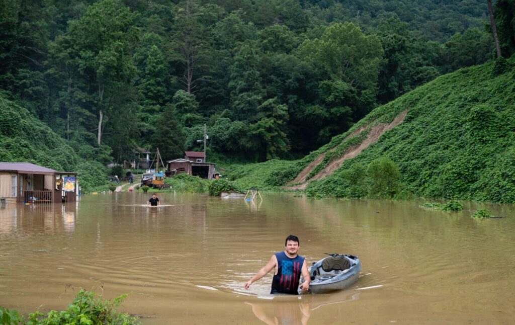
The Appalachian Mountain region has long endured frequent and devastating floods. From the shale-rich hills of West Virginia to the hollers of eastern Kentucky and the Blue Ridge Mountains of western North Carolina, communities have repeatedly witnessed creeks overflowing and valleys drowning in mud and debris. While climate change has intensified annual rainfall, another, less visible factor is compounding the crisis: the Halliburton Loophole. This exemption from federal regulations on hydraulic fracturing allows companies to inject millions of gallons of fluid underground with minimal oversight, further destabilizing the region’s already fragile hydrology and escalating the risk of catastrophic flooding.
The Halliburton Loophole: What It Is and How It Came to Be
The Halliburton Loophole was created by the Energy Policy Act of 2005, which amended the Safe Drinking Water Act (SDWA) to exempt most hydraulic fracturing operations from the Underground Injection Control (UIC) program.[1] The UIC program was originally established to regulate underground fluid injection and safeguard underground sources of drinking water (USDWs).[2] Prior to 2005, the Environmental Protection Agency (EPA) had the authority to require permits, conduct testing, and monitor subsurface injections, including those involving fracking fluids.[3]
This changed with the 2005 amendment, heavily supported by Vice President Dick Cheney, a former Halliburton CEO, and redefined “underground injection” to exclude “the underground injection of fluids or propping agents pursuant to hydraulic fracturing operations.”[4] Consequently, the EPA lost its authority to regulate the chemical makeup, injection pressures, or long-term impacts of fracking fluids.[5] Oversight now largely rests with state agencies, which in Appalachia are frequently underfunded, understaffed, and subject to political pressures.[6] The result is a fragmented regulatory system that leaves watersheds vulnerable to contamination, slope instability, and hydrologic alteration.
Connecting Fracking to Flooding: Hydrology in Hills
At first glance, fracking and flooding seem unrelated—one occurs deep underground, the other unfolds on the surface. Yet in the Appalachian Mountains, the two are deeply connected. The region’s folded shale, fractured sandstone, and legacy coal seams create natural pathways for groundwater flow. When millions of gallons of high-pressure fluid are injected into these formations, underground water movement is disrupted, potentially opening new fractures or reactivating dormant ones.[7] Without the SDWA’s UIC permitting requirements, these subsurface changes frequently go undocumented, leaving regulators unaware of dangerous buildups in groundwater pressure.[8]
When heavy rains arrive—and in Appalachia, they always do—these modified subsurface pathways amplify runoff.[9] Water that once seeped gradually into the ground may now be channeled directly to streams through fractures, raising discharge rates and peak flood levels.[10] The EPA’s 2016 assessment of hydraulic fracturing impacts found that these subsurface changes can “create or enhance hydraulic connections between deep formations and near-surface aquifers.”[11] In some instances, fracking fluids and brine have migrated upward through abandoned wells or faults, contaminating both groundwater and surface water sources.[12]
Surface disturbance further heightens the risk.[13] Fracking operations require clearing land for well pads, access roads, and retention ponds, which are often on steep, sensitive slopes.[14] These impervious surfaces limit infiltration and accelerate stormwater runoff.[15] When heavy rains pound barren hillsides, erosion worsens, stream channels become clogged with sediment, and flash floods grow even more destructive.[16]
West Virginia: Ground Zero for Legal and Hydrologic Failure
Nowhere are these dynamics clearer than in West Virginia. The 2016 West Virginia floods, which killed 23 people and caused over $1 billion in damage, were exacerbated by deforestation, slope development, and poorly regulated energy infrastructure.[17] Researchers have since argued that hydraulic fracturing and related industrial activity amplified runoff in already-fragile watersheds.[18]
A U.S. Geological Survey (USGS) study in the Monongahela River Basin found that stress-relief fractures—naturally occurring cracks in the bedrock—act as important groundwater pathways and are highly sensitive to changes in underground pressure caused by human activity.[19] Even deep injection activity can alter groundwater discharge patterns that sustain valley streams.[20] Research also shows that areas near shale-gas wells exhibit elevated groundwater pressures and disrupted base-flow dynamics, highlighting the connection between subsurface fluid injection and surface-water response.[21] These findings demonstrate how the Halliburton Loophole’s regulatory gap hinders the hydrologic review necessary to anticipate and prevent flood impacts.
Kentucky: Landslides, Injection, and the 2022 Floods
In eastern Kentucky, where steep terrain and shale formations intersect with intensive energy extraction, the effects of deregulation have been equally severe. The July 2022 floods killed more than 40 people and devastated entire communities.[22] Although extreme rainfall triggered the disaster, post-event analysis revealed that widespread landslides and debris flows were linked to saturated, fractured slopes already destabilized by mining and drilling.[23]
Kentucky’s oil and gas statutes lack robust requirements for cumulative hydrologic impact assessment or subsurface injection monitoring.[24] Because the Halliburton Loophole preempts federal UIC oversight, the EPA cannot require operators to model how injection pressures might interact with groundwater or slope stability. The result is a self-reinforcing cycle: weak regulation leads to altered hydrology, which amplifies natural hazards in already vulnerable mountain communities.
North Carolina: A Lesson in Prevention
Unlike its neighbors, North Carolina has so far avoided widespread fracking. In 2013, the state’s Mining and Energy Commission proposed rules to require chemical disclosure for hydraulic-fracturing fluids, but the effort was weakened by lobbying from industry groups citing trade secret protections.[25] Legal challenges and political shifts delayed comprehensive regulation, leaving the state with only partial transparency requirements.[26] If the Halliburton Loophole persists, any future expansion of fracking in North Carolina will likely proceed without essential hydrologic safeguards or baseline groundwater testing—raising the risk of destabilization and flooding seen elsewhere in the region.[27]
Legal and Policy Implications: Federalism at Its Breaking Point
The Halliburton Loophole undermines the Safe Drinking Water Act’s central goal: safeguarding underground drinking water from contamination and structural damage.[28] In hydrologically connected regions like Appalachia, this exemption threatens not just groundwater but also surface stability and flood resilience. By shifting oversight to states—without adequate funding, technical resources, or consistent standards—Congress created a regulatory blind spot at the intersection of energy development and climate risk..[29] As a result, fracking can move forward in flood-prone areas without federal review of hydrologic risks, cumulative injection pressures, or the interplay between slope geology and extreme rainfall.
Reform and Responsibility: Closing the Loophole for Climate Resilience
Congress should amend the Safe Drinking Water Act to repeal the 2005 exemption and restore EPA authority over hydraulic fracturing fluids under the UIC program. The Fracturing Responsibility and Awareness of Chemicals (FRAC) Act—introduced multiple times since 2009—would close this loophole, mandating chemical disclosure and groundwater monitoring.[30] In addition to reinstating oversight, regulators should embed flood resilience into permitting by requiring hydrologic impact assessments, vegetative buffers, and adaptive monitoring in areas with steep topography or high rainfall.[31] States and localities should implement complementary zoning and stormwater controls in energy fields to prevent destabilization and capture runoff before it collects in hollows. A coordinated federal, state, and local approach is essential to close both the legal and hydrologic gaps.
Ultimately, the Halliburton Loophole exemplifies a breakdown of environmental federalism. It removed crucial oversight precisely where cross-jurisdictional coordination is needed most: in watersheds that span county and state boundaries. In Appalachia, water flows downhill through communities that often lack the political power to challenge upstream industry. The loophole enables private profits while transferring the costs—damaged homes, contaminated wells, and repeated flood recovery—to local taxpayers. Repealing the loophole will not stop the rain, but it would empower regulators to ensure industrial activity no longer exacerbates natural disasters. Water always finds the gaps—and in this case, the most dangerous gap is in the law itself.
[1] Energy Policy Act of 2005, Pub. L. No. 109-58, § 322, 119 Stat. 594, 694 (2005) (codified at 42 U.S.C. § 300h(d)(1)(B)).
[2] Safe Drinking Water Act, 42 U.S.C. § 300h(b).
[3] Id.
[4] Id.
[5] U.S. Env’t Prot. Agency, Permitting Guidance for Hydraulic Fracturing Using Diesel Fuels (Feb. 2014).
[6] Mary Tiemann & Adam Vann, Cong. Rsch. Serv., R41760, Hydraulic Fracturing and Safe Drinking Water Act Regulatory Issues (2015).
[7] Granville G. Wyrick & James W. Borchers, Hydrologic Effects of Stress-Relief Fracturing in an Appalachian Valley, U.S. Geological Surv. Water-Supply Paper 2177 (1981).
[8] U.S. Env’t Prot. Agency, EPA-600-R-16-236, Assessment of the Potential Impacts of Hydraulic Fracturing on Drinking Water Resources (2016) (finding that “limited data availability and lack of consistent monitoring make it difficult to determine the full extent of hydraulic connectivity or subsurface pressure changes resulting from hydraulic fracturing operations”).
[9] Id.
[10] USGS, Water Resources and Shale Gas/Oil Production in the Appalachian Basin (OFR 2013-1137).
[11] U.S. EPA, supra note 8.
[12] Id.
[13] Id.
[14] Marcellus Shale Coal., Recommended Practices: Site Planning, Development and Restoration 7 (2012), https://marcelluscoalition.org/wp-content/uploads/2012/04/Site-Planning-Development-and-Restoration.pdf (listing surface disturbances for well pads, access roads, central impoundments, and pipelines, and recommending erosion and sediment controls).
[15] U.S. Env’t Prot. Agency, Erosion and Sediment Control from Energy Extraction Sites, EPA/600/R-18/041 (2018).
[16] Id.
[17] Martina Angela Caretta et al., Flooding Hazard and Vulnerability: The 2016 West Virginia Floods, 3 Frontiers in Water, 5 (June 2021).
[18] Id.
[19] D.B. Chambers et al., US Geological Survey, SIR 2014-5233, Water Quality of Groundwater and Stream Base Flow in the Marcellus Shale Gas Field of the Monongahela River Basin (2015), https://pubs.usgs.gov/sir/2014/5233/pdf/sir2014-5233.pdf.
[20] Id.
[21] Paul F. Ziemkiewicz et al., Evolution of water chemistry during Marcellus Shale gas development, 134 Chemosphere, 224, 226 (Sept. 2015).
[22] National Weather Service, July 2022 Significant River/Flash Flood in Southeastern Kentucky Summary (2023), https://www.weather.gov/media/publications/assessments/July_2022_Significant_River_Flash_Flood_SE_KY.pdf.
[23]Id.
[24] Ky. Rev. Stat. Ann. . §§ 353.500–353.720.
[25] Halliburton, Fracking, and the N.C. Public Records Act, SmithEnv’t Blog (May 3, 2013), https://www.smithenvironment.com/halliburton-fracking-and-the-n-c-public-records-act/.
[26] Id.
[27] Id.
[28] 42 U.S.C. § 300h(b).
[29] U.S. Gov’t Accountability Off., GAO-14-555, Oil and Gas Regulation: Opportunities Exist to Improve Oversight of Hydraulic Fracturing Activities (2014).
[30] Fracturing Responsibility and Awareness of Chemicals (FRAC) Act, H.R. 2133, 117th Cong. (2021).
[31] Id.